Brown's Fork Drag Strip (Hazard)
ClosedClosed No longer racing, but some of the track is still there.
- A coal miner's private airstrip used for pink-slip races
- Raced
- 1970s
- State
- Kentucky
- What's left
- A good length of the old track surface is still there, in poor to good condition.
- On the site today
- Housing development
- Raced on
- An airport runway
- Address
- 511 Browns Fork Road, Hazard
- Elevation
- 902 ft (275 m)
- Coordinates
- 37.24389, -83.24017
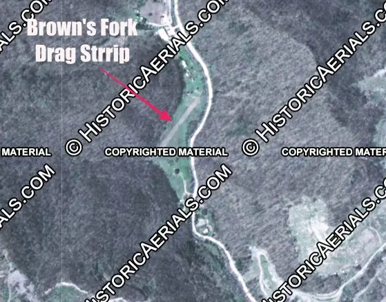
Drag strip researcher David Allio heard from a local that this was a private airstrip belonging to a regional coal miner, who opened it to locals for pink-slip races in the early to mid-1970s. It was at 511 Browns Fork Road in Hazard, with the strip running from 37.2436, -83.2403 to 37.2450, -83.2390, confirmed on a 1983 aerial photo. The site is now a housing development. Pinning it down was hard, since Allio was told it had been in three different places.
More in Kentucky
- Active Still racing today. Beech Bend Raceway Park (Bowling Green) 1956-present
- Closed No longer racing, but some of the track is still there. Bluegrass Dragway (Nicholasville) 1964-81
- Closed No longer racing, but some of the track is still there. Bluegrass Raceway/I-64 Motorplex (Owingsville) 1988-2023
- Closed No longer racing, but some of the track is still there. Campbell Air Force Base 1957
- Closed No longer racing, but some of the track is still there. Cedar Creek Drag Strip/Bullitt Dragway (Louisville) 1956-72
- Closed No longer racing, but some of the track is still there. Central Kentucky Drag Strip/Campbellsville Dragway 1959-66
- Closed No longer racing, but some of the track is still there. Kentucky Dam State Park Airport (Gilbertsville) 1957
- Active Still racing today. Lake Cumberland Dragway (Jamestown) 1990s-2016, 2023-present
- Active Still racing today. London Dragway 1999-present
- Status unknown Closed, but nobody has checked how much of the site survives, or the exact spot was never found. Manchester Dragway/D & J Dragway early 1960s-?
- Active Still racing today. McCracken County Drag Strip/Beacon Dragway (Paducah) 1968-77, 2008, 2013-present
- Closed No longer racing, but some of the track is still there. Mountain Motor Dragway (Isom) 1990-2016